Remember when I said in my last post that I was planning a DIY hiking event? Well, it’s (still) on and I did a training hike yesterday which felt really good and I’m still feeling kind of proud of myself for doing it.
This weekend is a long weekend for me, as Monday is Columbus Day/Indigenous People’s Day (choose your preferred name), so my first thoughts were “when should I hike?” and “what should I hike?” I was suffering from indecision until late Friday night, when I decided to do a solo hike of a loop trail in South Mountain: the Pyramid–National trail–Bursera (PNB) loop. Total distance is about 11 miles/18 km and total elevation gain is almost 2500 feet/762 m.
My thought was that if I finished that hike and could walk somewhat normally the next day, I would probably be able to finish my DIY hiking event. Well, I did finish my hike yesterday and I can actually walk normally today, so I’m cautiously confident that I will be able to finish the 7 hikes in my DIY event in one day. (I’ll continue training over the next month, though….I don’t want to assume anything!)
(FYI, the statistics for the PNB loop hike are just under half of what I would complete if I successfully climb all 7 summits in my DIY challenge. I suppose one could consider my PNB loop hike a test of my current fitness. I would say that I passed.)
I really enjoyed my PNB loop hike and REALLY REALLY enjoyed the cooler temperatures! The high temperature yesterday was only 28C / 82F….I started hiking at 7:45am because I didn’t have to start my hike at some awful early hour to avoid the heat….there was a nice breeze….the ocotillos were so green because of the recent rains we’ve received….it was just a nice morning. I even brought a baby Coke with me as a “halfway point” reward. As usual, it tasted AMAZING. It’s the little things in life!
Happy September, my dear readers! I hope your September is cooler than mine; although the calendar indicates that it is now autumn, here in Phoenix, the average high temperature is still hovering around 105F (40C), which sadly is lower than last month.
GO.AWAY.SUMMER.
Despite the summer-in-fall temperatures, I’m managing to look ahead to winter-in-Phoenix, i.e. November, and all of the lovely opportunities to play outside ANY TIME OF THE DAY. It will be SO NICE not to wake up at some unearthly hour just to breathe fresh air and not get baked/fried by the sun.
(Can you tell I am tired of the heat?)
One opportunity to play outside is Phoenix’s annual “7 summit challenge,” which occurs in mid-November. This event challenges hikers to hike 7 different summits in the Phoenix metropolitan area in one day. If successful, hikers will have hiked about 25 miles (40 km) over the day, achieving about 5000 ft (1525 m) of elevation gain. My SAT (self-appointed trainer) and I were on holiday in Canada when registration opened up, so we missed our chance….or did we? I really wanted to do this event and thought that I may as well organize my own DIY 7 summit challenge. (Why pay good money to hurt yourself when you can do it for free?) I’m currently in the initial stages of finding other willing “hiker-victims” and mapping out logistics.
Of course, in addition to planning my actual DIY summit challenge, I have to train for it. A friend suggested hiking Camelback mountain yesterday, a very popular local hike. Hikers can use 1 of 2 trails to the top, both of which are short (each trail is about 1.25 miles long) and steep (~1700 ft gain for each trail). However, instead of hiking up one side, she said we should do Camelback “over and back,” i.e. hike up one side and down to the bottom of the other side, then back up and over to where we started. “That sounds good!” I said.
The reality:
Start hiking at 5:50am, i.e. before sunrise. Temperature was in the low 70s/25C, so was bearable. Not having the sun beat down on you was also nice.
Watch sunrise! This was pretty and (almost) made the ridiculously early start (almost) worth it.
Become hot, sticky, and sweaty. Remain hot, sticky, and sweaty for the rest of the hike.
Worry about the possibility of falling and not being able to get back up due to leg cramps, fatigue, and general crankiness.
Cry with joy (internally) when we reached the car.
As a post-hike treat, I packed some baby Cokes into a little cooler bag. THAT WAS AMAZING. Do not underestimate the power of sugary carbonated liquid….magical.
I’m happy to report that my legs are still in working order and I’m looking forward to getting myself into better hiking shape so I can conquer the 7 summits….stay tuned. 🙂
On Saturday, my hiking trio (my SAT–self-appointed trainer–Ian, and myself) drove up to Payson to hike the Barnhardt trail. My longtime blog followers may recognize that name; it was only in January when we summitted Mazatzal Peak. Part of that hike included the Barnhardt trail, but unfortunately, we only got to experience the trail at the end of our hike, which meant a lot of what we saw looked like this:
My memories of Mazatzal Peak are not warm and fuzzy. They are cold, painful, and bring tears to my eyes. In an attempt to exorcise those unpleasant memories and to create new, positive ones of the Barnhardt trail, I suggested we hike the Barnhardt trail in daylight.
We started on the trail around 7:45am and the temperature was in the mid 70sF. It was still fairly humid, though, so I wasn’t feeling as cool as I would have liked. The trail is very pretty and we saw lush green vegetation all around us, due to the recent rains. We even saw some gorgeous butterflies enjoying the breeze. For the record, we did NOT see any gorgeous butterflies the last time we hiked this trail.
Beautiful butterfly on Ian’s sock.
SO GREEN!
Pretty sky.
More green.
I like the colour contrast between the green vegetation and red rocks.
I’m not sure how far we went, as there is no summit point for the Barnhardt trail (this trail connects up with numerous other trails but does not lead up to Mazatzal Peak or any other peak), but according to Ian’s phone GPS, when we were almost at 6000 ft, the humidity was gone, leaving nothing but fantastic temperatures with a lovely breeze. Don’t forget the pretty views! I think we probably hiked about 4 to 4.5 miles when we decided to stop for a quick snack break before heading back down to the car.
Panoramic view.
My Coke says it all.
A strange fruit we saw on a bush where we stopped for a snack.
Required selfie.
A cool grotto off to the side of the trail near our snack spot.
Did this hike erase my previous memories of the Barnhardt trail? No, not really. While hiking, I couldn’t help compare my previous and current experiences:
darkness vs light;
cold vs warm(er);
painful vs pleasant;
lost vs not lost;
no Coke vs Coke;
no one read the hike description vs I read the hike description; and
angry/in despair/scared vs happy knowing that our lives were not in danger (that is not a joke).*
In any case, I enjoyed THIS hike on the Barnhardt trail and am looking forward to Phoenix’s winter and all the great hiking that awaits us!
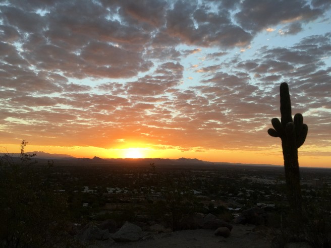
It’s August in Phoenix, which means it’s still hot….and muggy….basically, July and August in Phoenix is like living in a desert sauna. Sure, we Phoenicians get a fantastic winter season, but our “tax” for that glorious winter weather is that “dry heat”/monsoon sauna each summer.
What do Phoenicians do to escape the summer heat? One of the most popular things to do is to drive up to Flagstaff and camp, hike, or bike. Flagstaff’s elevation is almost 7000 feet, which makes for drastically cooler temperatures compared to Phoenix. That said, yesterday, my friend Crystal and I drove to Flagstaff in order to hike the highest point in Arizona: Humphrey’s Peak. (Apparently, we were not the only ones with that idea, because we saw a lot of people on the trail). Also, I just learned today that yesterday (i.e. August 4) was the inaugural National Summit Day–what a serendipitous piece of news!
The weather was pretty much perfect: sun, no chance of thunderstorms or lightning, a brisk 46F/8C at the summit. Humphrey’s Peak stands 12633 ft/3851 m high and is actually not a difficult hike; total round-trip distance from the Arizona Snowbowl trailhead just outside Flagstaff (the easiest trail of the 2-3 different trails to the summit) is almost 10 miles and total elevation gained is 3303 ft/1006 m. The biggest variable is whether altitude sickness will hit you. Crystal and I had hiked Humphrey’s before, but it had been a few years for both of us. We were both out of hiking shape too, so we agreed to hike at a moderate pace with breaks, if necessary (of course breaks are necessary!).
I’m happy to report that we successfully summited Humphrey’s and got to enjoy being cold! No altitude sickness for us, although we did experience the expected shortness of breath and leaden legs as we neared the summit. We got to the top in 3 hrs and 50 minutes and completed the descent in 2 hours 50 minutes, i.e. going downhill was much easier and faster. One of the best things about hiking is the food afterwards and we celebrated with some Chick-fil-a and Starbucks. Yay for cold summer temperatures, good company, successful summits, and FOOD!
The beginning of the hike–pretty meadow.
We met Sage, an award-winning Belgian sheepdog. His fur is very soft.
The saddle. Some people decide to end their hike here.
A view from the top.
Another view from the top.
Posing with the summit sign.
I remembered to bring a baby Coke on this hike–tasted so good!
Summer in Phoenix is not a joke. It is “normal” to have temperatures of 95F (35C) by 7am. But “normal” does not mean “enjoyable.” The heat gets oppressive, which means Phoenicians have to find places to escape to, if only for a few hours. That’s what we did today–we drove up to Pine (about 1 hr 45 minutes’ drive from home) to hike the Pine Canyon Trail, with our friend, Ian. Best part of the day? Hiking in the morning without the danger of heatstroke. Second best part of the day? Drinking my can of ginger ale (I didn’t have any baby Cokes!).
The Pine Canyon Trail starts at the aptly-named Pine Canyon trailhead, just outside of Pine, AZ. Ok, so the names aren’t the most original, but they work! Some online hike descriptions say that the distance end-to-end is 8 miles, while other descriptions say 12 miles. If one were to hike the trail “out and back,” that would have been a minimum of 16 miles, a distance none of us were ready to do today. So, we decided to hike about half of the trail, then turn around and hike back to the trailhead, for a total of 10+ miles. The trail is well-marked, easy to follow, and features a gradual (i.e. gentle) incline (at least, the first 4-5 miles we did were gentle).
It was a lovely day, with lots of pine trees, some manzanita trees, and lots of greenery due to the recent rains. Also, Pine is a lot closer to us than Flagstaff, which is the more popular escape option for Phoenicians in the summer. I can’t wait for the fall…!
Pine Canyon Trail is part of the Arizona Trail, a 790 mile trail that bisects Arizona.
What the heck have I done the past few months? Nothing exciting, which is why Memorial Day weekend was great! My SAT (self-appointed trainer) and I joined our friends Carl, Lifan, Steve, and Ian for our (sort of) annual mountain biking camping weekend near Prescott. I did go on a few “training” mountain bike rides in anticipation of the Memorial Day weekend trip, during which I saw a gila monster (!) and saguaro cacti in bloom:
A gila monster! So cool!
Pretty saguaro cactus blossoms.
Currently, there are fire restrictions in place all around Arizona, which means camping spots are super limited. A lot of campgrounds are closed, including most primitive camping areas. However, we decided to do the primitive camping thing at Thumb Butte, which was open (the fire pits were taped up as a visual reminder not to start campfires).
The temperature was lovely and cool, albeit windy (the highs were in the high 60sF/low 70s….a.k.a. low 20s celsius). I was actually cold and delighted in wearing my favourite puffy jacket.
Phoenix has been heating up a lot lately, i.e. we are basically back to cookie-baking temperature now, so enjoying the cooler weather in Prescott was a treat. Being outside at noon is always more fun when you’re not concerned about heatstroke.
The happy group.
More proof that I actually ride a mountain bike!
My SAT has gotten into archery recently, and brought his bow, arrows, and practice target on the weekend to practice. Here he is, pretending to be Robin Hood:
Whenever we camp with our friends, one of the highlights is making s’mores around the campfire. Sadly, that did not happen this year due to the fire restrictions. However, Lifan made some s’mores bark that was absolutely delicious! I would have included a photo of the bark, but we ate it too quickly. I am DEFINITELY making some s’mores bark for the next camping trip, even if campfires are allowed.
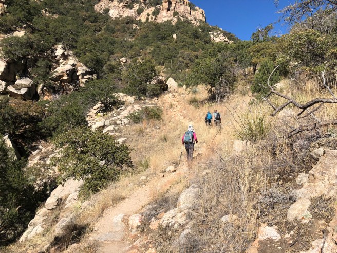
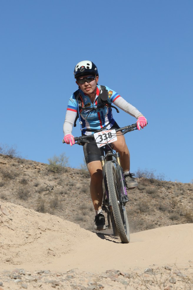
Yesterday, we (me, my SAT–“self-appointed trainer”, and our friend Ian) joined another Meetup group on a hike up to the highest point in the western Superstition mountains: Superstition Peak 5057. Not the most creative name for a peak, but it’s definitely descriptive. As you may have guessed, the elevation at the summit is 5,057 feet. (Official statistics from hikearizona.com: 7.8 miles round-trip and 3000 feet elevation gain.) It was a lovely day with good company, beautiful views, and an actual TRAIL! Another bonus of hiking with this Meetup group vs the last one: we took a few breaks! That last point is really important because that meant I could breathe.
We started from the Hieroglyphic trailhead in Gold Canyon, so named because of the petroglyphs you will see:
Waterfall and pool area in Hieroglyphic Canyon.
Petroglyphs!
(Clarification point: “hieroglyphs” refer to stylized pictures of objects that represent different words, syllables, or sounds, as found in ancient Egyptian and other writing systems. “Petroglyphs” refer to rock carvings, especially prehistoric ones. I think that the specimens we saw are actually petroglyphs because they looked more like rock carvings than a quasi-writing system, but I’m not an archeologist.)
After the canyon, we followed the trail up to the saddle. The trail is fairly steep the whole way, but the group took a few breaks to breathe, regroup, and enjoy the views. Some online hike descriptions warned potential hikers that the last mile before the saddle features a grade of almost 30%. My legs certainly felt the steepness of that section.
Early in the hike.
I like this saguaro cactus.
Getting higher…
Even higher yet…
Artsy photo of a large saguaro cactus.
We finally reached the saddle and had a last break before the final push to the top. The summit was probably about 10-15 minutes away from the saddle.
At the saddle. Note how flat the ground is.
View from saddle.
Our ultimate goal is to the right.
Then, the summit. The views from the top are fantastic and it was lovely to soak in the landscape (and to sit down).
Panoramic view from the top.
Enjoying the views.
There’s a lot of air below us.
Requisite summit photo.
We took the same trail back down and boy, was that hard on my quads! In addition to descending the same steep trail we took up, we had to deal with a lot of loose rock, which made the way a bit slippery in spots. Some folks ended up with minor cactus puncture wounds from accidentally grabbing onto them whilst losing their balance. Despite those minor setbacks, it was a great day to get out in nature and meet new people.
Have you ever had a dream in which you were running after something or someone and the harder you tried to keep up, the more you fell behind? Well, a similar experience happened to me last weekend.
Last Saturday, my SAT, Ian, and I joined a meetup group in an attempt to meet other potential hiking buddies. (The meetup website is a portal to thousands of groups categorized by activity/interest. After you join a group, you can participate in that group’s activities and hopefully, make friends!) The group we joined billed itself as a “fast pace group” that does “advanced hikes.” I thought we’d be ok, as we’ve been hiking hard hikes for the past month and haven’t died (well, perhaps I may have felt close to expiring when we did Mazatzal Peak recently). The scheduled hike was in the Tucson area: the “Window” via Ventana Canyon. According to hikearizona.com, the hike is 12.8 miles (round trip), boasts 4,310 feet in accumulated elevation gain, and takes about 8-10 hours to complete. I was a little concerned at my ability to keep up with a fast-paced hiking group, but my SAT was optimistic, citing our recent weekend hikes and my propensity to keep up appearances, i.e. ‘save face.’
We elected to meet the hiking group at the trailhead and left our place around 6:30am, giving us 2 hours to get to the trailhead by 8:30am. Unfortunately, we were not even 15 minutes into the drive when we noticed that we had slowed down a lot….and were in the company of dozens of other cars. Turned out that there was a bad accident up the freeway that was blocking traffic and the cars up ahead were being detoured. I contacted the hike leader and told her that we were stuck in traffic, would probably be late, and the group should go on without us. To be totally frank, I was sort of relieved that we would probably not meet the group (I don’t have to prove myself as a “fast hiker!”). However, things have a way of working out and we actually ended up meeting the group at the trailhead only 15 minutes late (they had just arrived themselves).
After exchanging greetings, we took off. And by “took off,” I mean “started running.” Good grief, the starting pace really scared me. I was 3rd in the line of hikers and the pace was the fastest hiking pace I had ever encountered. It really was more like running. Ian was behind me and I muttered to him that “this is really really fast!” He agreed. My SAT, on the other hand, was 2nd in the line and was chattering like a blooming chipmunk, not even pretending to be out of breath or terrified at how painful this day was going to be.
After a half hour or so, the trail got steep pretty quick and the hike leader slowed down a lot. Half of the group (all guys who had 1% body fat and didn’t need oxygen to climb steep mountains) told my half that they were going to “run up for a bit.” I would have said something, but that would have required air and I didn’t have any to spare.
Most of the hike was pretty challenging for me, not because of the amount of elevation gain, but because of the overall pace. The pace, while not the terrifyingly fast pace initiated at the start of the hike, was still strong and I was struggling at times to keep up with the group (but I DID keep up, as my SAT kept on telling me).
Aside from my SAT (who took this picture) and one other group member, my perspective during the hike was from the very back. Sigh.
This group hike was also the first time that there were NO BREAKS. I’m used to having a break or two on the way to the top. This group does not stop. The break occurred at the top. Lastly, because I was hiking faster than my normal pace, my legs were shaky a few times….so much so that my SAT literally had to give me a boost up over a number of large steps/boulders. He was actually lifting me up. It was sad (for me) and amusing (for him).
Despite my pain, I still have to say that the group was pretty nice and we enjoyed getting some food with them after the hike (by the way, it’s a LOT easier to pretend that all is well when you’re done the hike, sitting down, and eating good food). The temperature was lovely and there were great views from the top. I also really enjoyed the break we had at the top. Very much. As a side note, total hiking time was just under 6 hours. (Remember the estimated time I cited of 8-10 hours? Apparently, that timeframe is only for people who want to breathe during their hike.)
Here are some views from the “Window:”
Pretty rock formations near the top.
One view from the top.
If you look closely, you will see fatigue, resignation, and fear in my eyes.
Standing in the “Window.”
Another view from the top.
Our new friends. Their smiles are genuine. Mine is (mainly) manufactured for the picture.
(*not true. I just wanted an attention-grabbing headline.)
Yesterday, my S(elf)-A(ppointed)T(rainer) and I completed a hike we’ve been wanting to do for a while: South Mountain’s National Trail. Over the past few months, we have been slowly tackling the peaks around the Phoenix valley and have kept the National Trail on our radar for when the weather is cool and when our legs have been trained up a bit more. My SAT asked his work friend, Matt, to join us for this adventure, to which he agreed. (For the record, Matt told my SAT that he wasn’t in great hiking shape. Cool! I thought I’d be able to keep up with him at least, or maybe even make him feel inadequate by hiking faster than him. Well, Matt lied. He’s in plenty good hiking shape. Lying isn’t cool, Matt.)
The National Trail is 13.71 miles long (22 km) and gains 2,611 feet (796 m) in elevation. In an effort to be environmentally-conscious, we hiked to the trailhead from our house, adding 3.25 bonus miles. Yay us! However, since we were only doing the trail end-to-end and did NOT want to do a round-trip hike (that would be about 35 miles of pain), we had to drop off a car at the end….which was not being environmentally-conscious. Boo on us. Anyway, we knew our limitations, so about an hour before Matt was to arrive at our place, my SAT and I drove both our vehicles to the end point, then drove back home together in one vehicle.
The weather was great for a lower elevation hike (trailhead sits at around 1400 feet): it was cool (high of 14C / low 50s F) and partly cloudy with 0% chance of precipitation (true, even though I did feel a few drops at one point). [Note: a thru-hike is when one hikes a long-distance hike end-to-end within one hiking season. Examples of iconic thru-hikes include the Pacific Crest Trail (PCT), the Continental Divide Trail (CDT), and the Appalachian Trail (AT). Obviously, my use of the term “thru-hike” to describe what my party did today is for humorous purposes only!]
We started our hike on the east end, which is the more popular end. As we hiked west, we saw fewer people and mountain bikers (the National trail is also a popular mountain biking trail). However, we did see a horseback rider and his dog, which was unusual. Another surprising thing we saw was a summit register. Generally, summit registers are on peak summits for hikers to sign. Instead of marking an actual summit, the National Trail summit register marked the highest point on any trail in the park. The last surprising thing we saw as we were firmly on the west side of the park was a cholla cactus forest.
A man, his horse, and his dog!
I like summit registers.
Go team!
So many cholla cacti.
I’m happy with our day today for a number of reasons:
we got some more good hiking training in;
we got to do a hike “close to home;”
we didn’t have a huge drive to the trailhead (other than setting up the car shuttle);
we got to see the remote west side of South Mountain;
we got to hang out with Matt!; and
we got to eat a lot after the hike! (We went to a local Mexican restaurant to refuel and rehydrate.)
Stay tuned for more hiking adventures!
All by myself on the trail.
Gray skies, but not a gloomy day.
At the end of the trail…but we still had to hike a mile to the car!
In our quest to hike the biggest peaks in and around the Phoenix valley, we decided to attempt Mazatzal (“Maz”) Peak, the highest point in central Arizona and the Mazatzal Mountain range. Maz measures 7903 ft / 2409m in elevation. My SAT’s (self-appointed trainer) GPS said that we hiked 12.4 miles / 20 km and gained 4185 ft / 1276 m. That GPS did not measure the large number of scratches, bruises, and overall pain we incurred during the hike. Let me explain…
When my SAT chose Maz Peak as our weekend challenge, he neglected to inform me or our friend Ian (our delightfully agreeable hiking buddy) that he did not read any of the multiple hike descriptions he found. Therefore, we all assumed that we would be hiking on a groomed trail and that we should be finished the hike by mid-afternoon. That was mistake #1.
We left Phoenix at 6:45am after picking Ian up and arrived at the trailhead at 8:17am (Maz Peak is near Payson, AZ). After organizing our stuff, we started the hike by 8:30am, choosing the “Y Bar” trail for the ascent portion of the hike. The trail was a bit chunky in sections, but was definitely a clear path. Views were pretty and we noticed A LOT of manzanita bushes along the way (this is foreshadowing…).
The “green” stuff = manzanita bushes.
The trail is my friend. Note the green on the hills in front of me = manzanita bushes.
Around mile 4, we noticed that the trail just…vanished. My SAT checked his GPS (he downloaded a gpx track recorded by a previous hiker) and said that the route just goes…up. We looked up:
The GPS said we were supposed to go up the red rock. My stomach just dropped.
At this point, we had a LOT of climbing to do. Most of the climbing was bushwhacking, or forcing one’s way through manzanita bushes and thorn bushes. We also had to climb up little cliffs, like this:
See if you can find some cacti hidden in the red rocks.
I’m smiling here, but that was purely for the camera.
It was very slow going. Because none of us thought to bring an axe, the bushwhacking part was just plain annoying. Good thing we all wore long pants and shirts. After 5 hours, we reached the summit. I think I almost cried, and not because of the views.
View from summit.
More nice views.
Humphreys Peak, the highest point in AZ, in the distance.
Geological survey marker on the summit.
Again, we are smiling, but it’s (mostly) for show.
We were the first to summit in 2018! Maz Peak is not climbed often; the summit logbook only had 2 entries for 2017, March and October.
Now that we made it to the top, how do we go back down? We all agreed that going down the way we came up was NOT a feasible option. That left us with going down “the other side.” So, we started our way slowly — the word of the day — making our way through the snow and rocks and those dratted bushes. Our goal was to hit the other trail (the Barnhardt) before sunset. We kept moving down the gully over boulders and pine logs, instead of staying on the ridge as the online instructions directed (this was mistake #2). Because we were descending in the gully, we ended up stopping at a couple of points because we were “cliffed out” (i.e. when you want to climb down a mountain, but find yourself on the top of a cliff and have to find another way down). After much tedious work, we finally FINALLY reached the Barnhardt trail after only 3 hours.
We just descended from the summit into the gully. Again, Ian’s smile is mainly for show.
Making my way over the millions of boulders and logs in the gully!
We had to climb down stuff like this rock wall.
A wide-lens perspective of what we had to go through to reach the trail.
Because I did not want to be dramatic or anything, I did not indulge in my first reaction upon hitting the trail (i.e. kissing the ground). Being on a trail again felt amazing. Realizing that we had another 2+ hours to hike back to the car was not as amazing, but hey, we made it to the trail with about an hour of daylight left. This is what we saw in the waning light of day:
The Mogollon Rim in the background, just below the sunset colors.
More prettiness that *almost* distracted me from the fact we had 2+ hours left to hike.
Pretty light on the hills of dratted manzanita.
Ok, so it was pretty!
We finally made it back to the car at 7:17pm, which meant that we were “out there hiking” for almost 11 hours! (Of course, we weren’t moving the whole time, as we took some breaks to eat, check the GPS, or cry (internally).) We thought about going for a celebration dinner, i.e. “We made it out alive!” dinner, but decided to go for something fast and ended up grabbing some Chipotle when we got back to town.
Final note: during the drive back, I read the hike description that Ian and I thought SAT read. Turns out that after my SAT read the first paragraph, he thought “hey, that doesn’t sound too bad! Since we’ll be on trail the whole time, we’ll just wing it.” THAT WAS A BAD DECISION. The first paragraph of the hike description says this: “This is a loop hike beginning at the Barnhardt Trailhead. It takes the Barnhardt Trail to about the 4 mile point, freestyle your way to the top, then a fairly direct route down to the Y Bar Trail for the return.” If my SAT read the NEXT paragraph, he may not have been so cavalier about the hike, because the writer indicates that 1) the Maz Peak hike is the most difficult he’s done, 2) there is a lot of route finding and bushwhacking, and 3) his accompanying GPS route is “possibly not the best.” And that route was the one we used. Read the full hike description for yourself for more detail on how challenging the route is (we actually ended up doing the reverse of the hike description writer’s route).
Next time my SAT plans a hike, Ian and I are not going to agree to do it so readily.
Before any of you comment on how unhealthy my resolution is, let me explain. I consider myself a healthy eater and primarily eat a vegetarian/vegan diet, i.e. no meat. Junk food is not a staple of my diet. However, I do let myself enjoy a treat or two after a big hike or bike ride, like a Coke or fries. Therefore, I figure as long as I engage in physical activity, I can eat junk food! This may be a resolution I can keep….
Today, my SAT (self-appointed trainer) and I hiked Arizona’s Mount Ord, which is the second-highest mountain in the Mazatal Mountain range (7128 ft / 2173 m). Some online accounts record the hiking distance to be 14 or 15 miles round-trip and the elevation gain to be anywhere between 3800–4720 ft (1158–1440 m). Our Garmin recorded the following statistics:
round-trip distance: 12.66 miles (20.4 km)
elevation gained: 3890 ft (1186 m)
Whatever the “true” statistics are, all I know is that my legs are sore. It’s an easy hike to follow, as you are on a jeep service road the entire time (the road is heavily eroded for the first 5 miles then comes to a junction with a newer, better quality service road for the rest of the way up to the top). However, all of the views along the entire trail/road are beautiful. (This was good, because the higher we hiked, the more we hurt….but the views were a pleasant distraction.) For instance:
Near the beginning of the hike.
Lovely purples!
Beautiful views the entire way.
I like rocks.
More views!
Tree tunnel.
Manzanita bark.
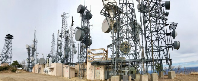
At the summit, we saw a cluster of communication towers:
And more amazing views, this time of the entire Phoenix valley:
Look at how far you can see!
Another bird’s-eye view.
Requisite summit selfie.
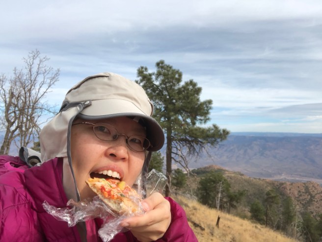
We were pretty hungry when we reached the summit. Remember my resolution of eating more junk food? Here’s me eating some leftover pizza on the summit:
On the way home, we went through a McDonald’s drive-thru so I could get some fries and a Coke. Both were consumed quickly. Overall, it was a successful day and we are excited to “bag” more peaks and eat more junk food!
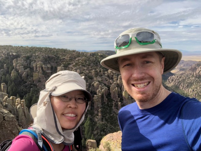
My S(elf)A(ppointed)T(rainer) and I spent the last weekend of 2017 camping and hiking in the beautiful Chiricahua National Monument. (Fun fact: according to a Jesuit priest named Juan Nentvig who lived in the mid 18th century, the name “Chiricahua” is an Opata word meaning wild turkey. Apparently, the Chiricahua mountain range was known for the wild turkeys who could be found there. However, by the mid 1900s, most of the turkeys were gone.) I don’t know why more people don’t know about this amazing place, but was sort of glad more people did not know about it because it was wonderful to have the place almost all to ourselves! The official webpage uses the phrase “a wonderland of rocks” to describe the landscape, and that phrase is very appropriate. We did 2 hikes, the “Natural Bridge” trail and the “Big Loop” trail (which was made up of several smaller loops). The first hike was lovely and features a pine forest and a small water-carved rock bridge at the end of the trail. The “Natural Bridge” trail is the least used trail, according to the official website, but the 4.8 mile/7.8 km hike is definitely worth doing, with its pretty woodland landscapes. However, the “Big Loop” is the hike that passes by all of the amazing rock formations. If you do the whole Big Loop, you will have hiked 9.5 miles/15.4 km and seen otherworldly rock landscapes. My words can’t do the scenery justice, so I’ll leave you with the following pictures:
Organ Pipe Rock Formation
A valley during the “Natural Bridge” hike.
The “Natural Bridge!”
Testing my muscles.
Perfectly balanced rock.
Pinnacle Balanced Rock…just as the sign says.
Skipping through a little slot.
Wonderful view.
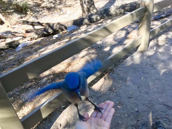
We stayed in the Bonita campground (the only campground in the park). The campground has running water, flush toilets, and lots of wildlife! There are 4 different ecosystems that pass through Chiricahua National Monument, which means that there are a lot of different animals that call the area home, including deer, mountain lions, bears, skunks (all 4 North American varieties live in the Chiricahua National Monument), and birds. The area is a birdwatcher’s paradise (according to the official website, about 200 different bird species have been documented in the area). We enjoyed the numerous Mexican blue jays that hovered around our campsite, waiting for us to drop crumbs. I actually fed a Mexican jay from my hand!
We ended our New Year’s weekend by watching the moon set and the sun rise. Happy New Year to all of you and get out and enjoy nature!
As I mentioned in my last post, my S(elf)A(ppointed)T(rainer) and I spent the Thanksgiving holiday weekend seeing lots of new things. Our original plan was to camp overnight in White Sands National Monument, check out the Carlsbad Caverns, and see whatever other interesting things along the way as appropriate. Well, like many a well-intentioned plan, ours fell apart. SAT was hesitant about driving more hours to get to Carlsbad Caverns, then facing a massive drive home….also, he was playing the “I have so much work to do” game and wanted to get back home early enough to have a bit of time left in the weekend to clean up and do those adult-y things before the work week begins, like grocery shopping and laundry. Therefore, we (that is, me) came up with a revised itinerary: White Sands, Las Cruces, and a roadrunner.
We reached White Sands around 1:30pm on Friday. (Fact #1: White Sands National Monument neighbours a couple of NASA missile ranges. Make sure to check the White Sands website for closures, because if there is missile testing, the Monument is closed to the public.) As my title indicates, there were no planes (or missiles)! When we arrived, we noticed that there were hundreds of people there too. Looks like holiday weekends make national monuments popular. (Fact #2: if you want to secure one of the 10 first-come, first-served primitive campsites, arrive by 11am or noon at the latest. We arrived around 1:30pm and did not secure a campsite.) Therefore, we decided to do the longest hike in the monument (5 miles) and play in the sand along the way.
White Sands is amazing. As the name suggests, the sand is white. As the sun was setting, the sun’s rays cast a lovely golden glow over the sand.
I had previously looked up the GPS coordinates of a few free primitive camping spots as potential places to camp for the night. (“Primitive” campsites are exactly that. There is no water, running or otherwise, no bathrooms/outhouses, nothing. You need to bring everything you need to survive, like food, water, and a tent…..and you need to “pack out” all trash, including human waste. But….it’s free!) My SAT was NOT looking forward to finding the primitive campsite in the dark (it was now after sunset), setting up the tent in the dark, or trying to sleep in a cold tent. Therefore, to appease his delicate nature, we ended up getting a room in nearby Alamogordo. Upside: cheap rate, really clean, reliable wi-fi. Downside: queen bed (SAT thinks we got a double bed) and the loud trains that rumbled nearby nearly every hour. SAT didn’t get much sleep due to the trains. He is a very light sleeper. The trains only woke me up once. I am a very good sleeper.
The next morning, we drove out to Las Cruces to check out a cool coffee shop, farmer’s market, and the historic Mesilla plaza, just outside of Las Cruces. The plaza had a number of cute touristy shops featuring chocolate, jewelry, and other such knickknacks.
(L to R: Mark charging himself up at the Tesla charging station in Las Cruces, NM; Basilica San Albino Catholic Church in Mesilla Plaza; a shrine to Our Lady of Guadalupe in Mesilla Plaza)
As we were leaving Mesilla Plaza, I was looking out for the famous “recycled roadrunner.” Very soon, we realized we were on the wrong side of the freeway….so we drove our one automobile to the nearest exit off of the freeway and drove a mile or so in the other direction to the rest stop in between mileposts 134 and 135. According to roadsideamerica.com, the roadrunner is worth a detour. Also, the rest stop is an award-winning one! I have no idea why the rest stop is considered “award-winning,” but the roadrunner is pretty cool.
New Mexico is a pretty interesting state. Next time, we will make sure we arrive at White Sands in the morning to secure a campsite and we will DEFINITELY visit Carlsbad Caverns.
So. It’s been a year since I last posted a blog on this neglected site. I wish I could say that the reason I haven’t blogged the past year was because life was so incredibly exciting! Nope. I’ve just been preoccupied with work and doing the regular home improvement stuff that first-time homeowners tend to get caught up in. However, this winter, there are a few good changes as compared to last winter. First, I’ve taken this season off from accompanying my choir, which means I have weekends off! Second, it’s winter in the desert, which means it’s safe to go outside! (Remember that “winter” in the southwest means “awesome weather” and “summer” in the southwest means “death due to heat exhaustion and dehydration.”) Third, because of reasons one and two, I’ve been doing some more hiking lately.
Two weekends ago, my SAT (“self-appointed trainer”) and I teamed up with our friend Ian to hike Wasson Peak, just outside of Tucson. This hike is considered to be a moderate trail hike: 7.5 miles (round-trip) and 1900 ft elevation gain. It was an overcast day, so temperatures were on the cool side. I enjoyed stretching my legs out and remembering what it felt like to do a long walk.
(1: pretty cactus pattern; 2: SAT and Ian near beginning of hike; 3: view of what we have hiked; 4: view from top; 5: view from top; 6: summit selfie)
~~~~~~~~~~~
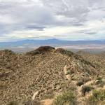
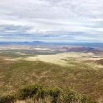
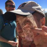
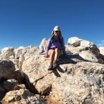
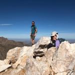
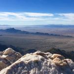
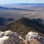
Yesterday, SAT, Ian, and I successfully summited Quartz Peak in the Sierra Estrella mountain range. The top of this peak is made up of white quartz boulders, thus, the (unimaginative) name. This hike is a workout! It’s almost 6 miles long and gains about 2,550 feet in elevation (my legs hurt yesterday). From the top, you have great views of the Phoenix valley while relaxing on the pretty quartz rock. Two extra cool things about this hike include the scrambling that you have to do to reach the top and the many pieces of mica available near the top. The drive to the trailhead is a bit of a chore: the last 5-7 miles is on a dirt road that requires a high-clearance vehicle (preferably 4×4).
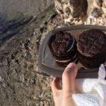
(1: our goal is the white peak!; 2: SAT peering at me through a transparent piece of mica; 3: sitting on top of the peak; 4: peek-a-boo!; 5: view from the top; 6: another view from the top; 7: I made vegan Oreos to enjoy at the top….and they were GOOD.)
What’s next? Well, my SAT and I are planning to visit White Sands Monument in New Mexico over Thanksgiving weekend, which should be really cool. Stay tuned for the trip report!